Emerald Acropolis Project
Cross culturally and throughout history, no cities and civilizations arose without religion. So, is religion, as the lived understandings of people’s relationships to spiritual, numinous powers, that which leads to urbanism? Were their spiritual reasons for the earliest “cult centers” and “cosmic capitals”? Psychological and functional explanations are by themselves insufficient to answer such questions, in part because they are rooted in a modern western cultural logic and in part because they lack historical perspective. We need to rethink religion and urbanism simultaneously from non-modern, non-western cultural-historical perspectives. Basically, what do religions do, historically speaking, such that urbanization is inseparable from the doing of it?
We think that we can answer that question, and the time has come for a major rethinking of the religious foundations of urbanism, particularly in the Americas and Asia. As revealed by recent discoveries from Stonehenge in England to Catalhoyuk and Gobekli Tepe in Turkey, archaeological insights into religion can dramatically alter our most basic understandings of human history. Similar insights with regards to the origins of urbanism have been hindered by the conceptual baggage of a century of economic models, where religion was little more than an ex post facto legitimation of an economic phenomenon. However, certain unusually large and precocious “cosmic” cities in the Americas and Asia come with less baggage, especially Cahokia.
 The “Emerald Acropolis Project” is a multi-year, multi-disciplinary examination of the religious foundations of urbanism and the broad relationships of the cosmos to human history. Through a four-pronged project involving fieldwork, computer-aided experimentation, and focused cross-cultural comparisons, we are interrogating the complex causal linkages between place, experience, and human and non-human agencies that, from recent theoretical vantage points, underpin emergent religious orthodoxies and the earliest cities. Based on what is one of the best-documented cases of city formation known to archaeology, we posit that, for all intents and purposes, a singular convergence of people with the powers of the earth, wind, water, and moon at a specific location caused the American Indian city of Cahokia in the central Mississippi valley (ca. AD 1050-1350). The specific site, called the Emerald Acropolis, holds answers to questions of what religions do and how they do it. A sweeping new religious vision seems to have been created at Emerald that afforded unprecedented relations between people and the animate powers of the world as Native Americans at the time understood it. There, people lived cosmic relationships.
Although Cahokia was a relatively late bloomer in the global history of civilization, it is widely recognized to be the most extensive ancient American archaeological complex north of Mexico, with the biggest pyramids, the most expansive plazas, the greatest population density, and the finest pots, chipped-stone tools, and carved sculptures, etc. In many ways, Cahokia is similar to other unwieldy, precocious politico-religious and urbanizing developments in the Americas and China (e.g., Puebloan Chaco Canyon and Paquimé, Olmec San Lorenzo and La Venta, Andean Tiwanaku, late Neolithic Liangzhu). Such places are centered on civic-ceremonial cores of monumental constructions that seem to gather unto themselves materials, powers, and peoples from the outside world. Comprised of three adjacent complexes or districts (Cahokia, St. Louis, East St. Louis), the city of Cahokia encompassed elite ritual-residential areas, ordinary farmer neighborhoods, public zones, and restricted or walled areas. Recent public-archaeological excavations at Cahokia’s East St. Louis precinct by the Illinois State Archaeological Survey verified three of these four features. They also verified Pauketat’s “big bang” model, which holds that Cahokia was planned and built at a tremendous scale in short order. That which we see today as the Cahokia State Historic Site is the core of one precinct constructed at the beginning of the Lohmann phase (1050-1100 CE) by thousands of farmers/laborers. The landscape and social fabric beyond the city limits was also radically transformed through labor projects, ceremonial events, and central rituals that included periodic human sacrifices of a few to dozens of people, primarily women.
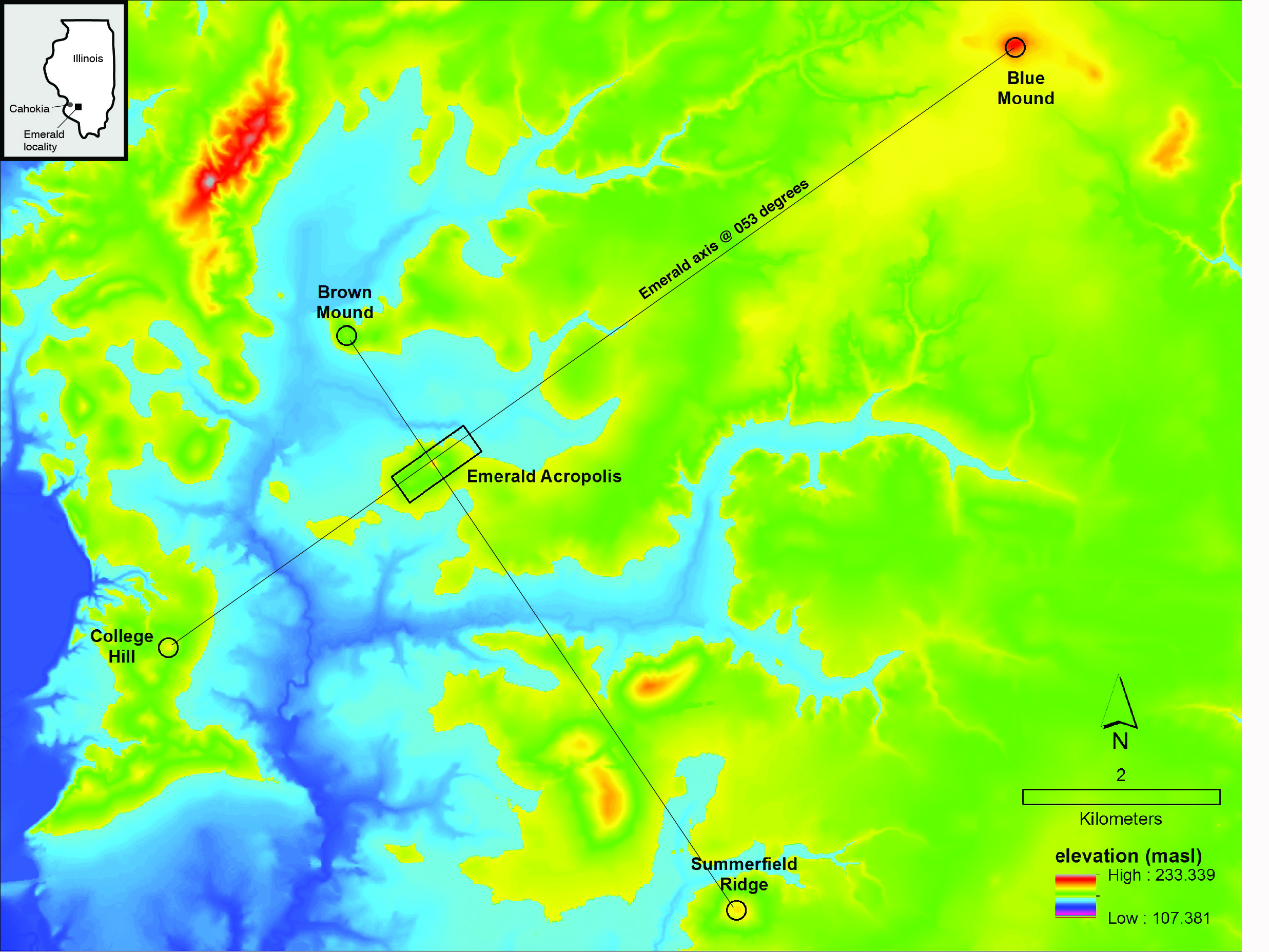
 The organizational axes of the central precinct if not the entire regional landscape are apparent in a causeway that runs from a burial mound north 1.5 km to the largest plaza and earthen pyramid, Monks Mound, which rises 30 m above the floodplain of the Mississippi River in which the city’s ruins sit. Around this axial plan were lesser pyramid-and-plaza clusters and neighborhoods of people living in small, semi-subterranean and rectangular pole-and-thatch buildings. Within a 30 to 50 km radius of this core, rural “nodal” sites seem to have integrated scattered farming populations presumably through local religious rituals. Some of these farmers were immigrants, of which there were likely thousands at Cahokia and in the hills east of the central complex. At the same time and hundreds of km to the north, a series of outliers, some possible Cahokian colonies, expatriate and copycat settlements, or missions have been identified. Three years of Mississippian Initiative excavations (2009-2011), funded by the National Science Foundation (Pauketat, P.I.), at one such 11th-century settlement in western Wisconsin, named Trempealeau, have shown it to be a Cahokian religious shrine founded at or just before AD 1050. It appears that Cahokians were there to occupy an unusual landform in this locality, perhaps communing with the non-human or ancestral spirits of this place and its many ancient burial mounds. The implications of Mississippian Initiative, along with our theoretical turn toward a experiential theory of religion and ongoing site destruction has led us directly to the Emerald Acropolis Project.
 The Emerald acropolis and the surrounding hilly prairie-scape, even today, provides a powerful visual experience of an open unobstructed view of the eastern horizon, even impressing Charles Dickens during his visit to this prairie in 1842. In an earlier study, Pauketat pointed out the precise correlation of the Emerald site’s primary 53-degree axis with a lunar maximum moonrise, which takes place during one out of every 18.6 years. Halfway through that cycle, the moon rises and sets within a much narrower envelop on the horizon, known as lunar minima. Both maximum and minimum moonrise and moonset observations are known to pre-date Cahokia and Emerald in Hopewell and Chaco culture contexts in Ohio and New Mexico. However, their convergence with and impacts on the world of the Cahokians, we propose, was a primary reason for the region’s unique urbanization.
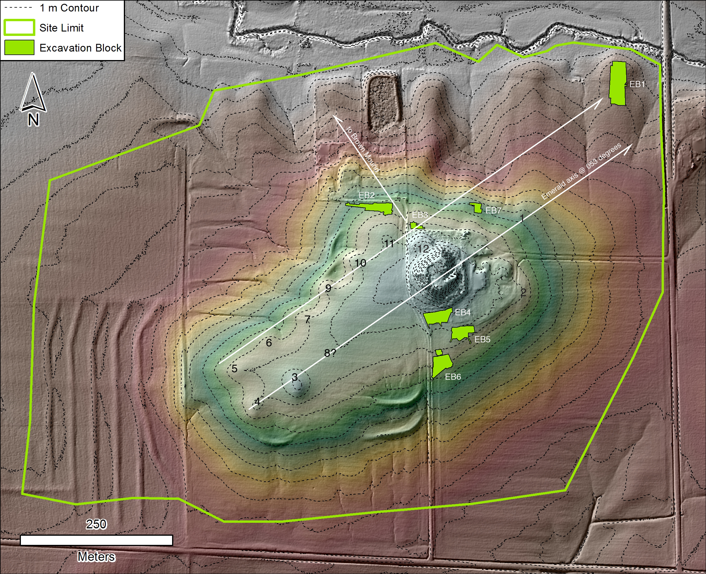
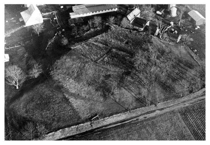
Little investigated before 2012, the Emerald site actually sits at the end of an ancient 50-meter wide roadway or avenue that ran for 24 km from Cahokia east to this grass-covered hilltop and its 12 faceted mounds. The site’s “Great Mound” is a central 6-m high flat-topped rectangular pyramid with a lower terrace on its northwest side. The avenue, recognized since the early 1800s, is easily seen to run directly to the foot of the Great Mound. Two smaller, related mound centers are located nearby, one on this same roadway. Excavations at one of them, Pfeffer in 2000, 2007 and 2008, are being analyzed as part of the Richland Analysis Project (with funding requested from NEH). Minimally, the site confirms the lunar angles and temple-based religious rituals evident at Emerald. Thousands of Cahokian farmers lived nearby, making up the so-called “Richland Complex,” and significant numbers of them appear to have been immigrant farmers. The analysis of excavations of some 226 buildings at four of the most important of these sites (Halliday, Grossmann, Pfeffer, Hal Smith) provide the backdrop against which the newer data from the Emerald site can be contextualized.
Project excavations at Emerald began in 2012 via the Historical Society of Boston’s “Religion and Innovation in Human Affairs” (RIHA) program (funded by the John Templeton Foundation). Through targeted block excavations, test trenches into the primary mound, geophysical survey, and pedestrian survey (walking over farm fields to locate additional sites in the vicinity), we can now infer that Emerald was an overbuilt complex of pole-and-thatch architecture, aligned mounds, and great upright posts. In our excavation blocks, we have identified the remains of more than 140 pole-and-thatch buildings or substantial reconstructions of those buildings. Most date to about 1020-1120. Ritual deposits are frequently found on their floors, ranging from burned mats and hides on floors to traces of sprinkled pigments and one human offering (which has been left in place as encountered). About 15 percent of the buildings are “shrine houses” with yellow-plastered floors and floor niche pits; they were given special treatment after they were dismantled. Others are temples, rotundas, sweat baths, T-shaped medicine lodges, and intermittently used housing (with little to no associated domestic refuse), the latter probably built for sheltering visitors. Many were aligned either to the moon and the landscape around the acropolis or, less frequently, the sun at its annual extremes. Such associations, we argue, was a way of “animating” them, allowing people to commune with the assembled powers or enabling the powers to mediate human beings.
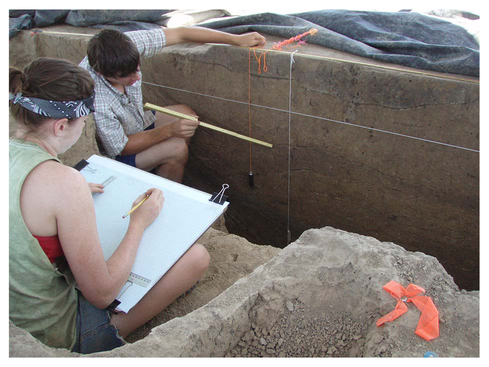 The dating of such buildings in association with the other Cahokian-public and religious buildings as they were ritually dedicated or closed in alignment with the moon is critical and requires a sound footing, and our Bayesian model of AMS dates supports an interpretation that the site was occupied and architecture constructed in a series of pulses timed to “lunar standstills.” So too does the history of dedicatory or closure practices in connection with these buildings. What was being connected to living people, otherworldly powers (i.e., Wakanda, Manitou, Waruksti), and elemental forces (fire, water, wind, etc.) in or through these special buildings and how? What were the affects of such convergences on people?
At the simplest level, if the Emerald site and avenue pre-date Cahokia’s mid-11th-century expansion, as now seems plausible, then the convergence of people, powers, and the moon at a great ritual shrine complex connected to Cahokia via a formal avenue may have been that which pulled immigrants into the region and led to Cahokia’s great AD 1050 transformation. If it was significantly expanded and maintained at 1050 by Cahokians, also plausible, then knowing the ritual associations at the moment of expansion and knowing the identity of the builders (Cahokian or non-Cahokian) is equally critical, helping to identify how the spiritual powers of this place were entangled with an increasingly orthodox Cahokian religion. In short, the precise ways in which the cosmos, earth, waters, fire, ancestral spirits, and other animate powers, as common to Native Americans, were affecting the proto-urbanizing development in the region is being recovered by our careful study of micro-stratified deposits in association with building floors, wall and roof posts, and basin fills.